Drone sensors: a visual extension of the agronomist and powerful allies for the farmer
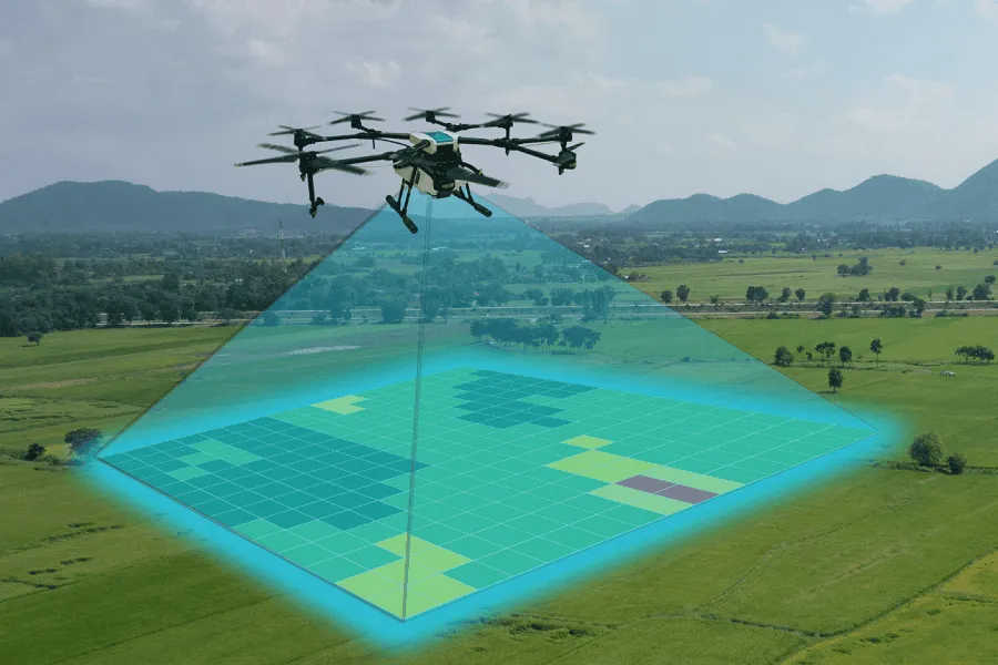
Drone sensors for precision agriculture
Introduction
In recent years, the spread of technology in agriculture has become increasingly widespread, especially monitoring and data acquisition tools. The reason is simple: data is valuable for acting rationally in the field, saving time and resources.
One of the key factors is tailoring the offer, because every farm has specific needs and different investment capacities. Cost is certainly the most pressing issue, as it could limit the spread of precision agriculture, especially in Europe, where the majority of farms have an area of less than 10 hectares.
In this context, drones equipped with sensors offer an accessible solution and make it possible to obtain precise information without costly infrastructure, while also considering the possibility of using third-party services. Agrobit offers the iDrone service for aerial photogrammetry, creating RGB, multispectral and thermal maps, prescription maps, 3D models and advanced data processing. To learn more about the services offered, you can read the dedicated article iDrone: the drone as a powerful ally for the agronomist.
Drone sensors
The aim of this article is to provide an overview of the sensors that can be fitted to remotely piloted aircraft, or drones.
Let’s start with the basics: what is a sensor? Technically, it is a device capable of detecting a physical quantity (for example, temperature, humidity, reflected light) and translating it into interpretable digital data. More simply, sensors are “eyes” that collect information in the field, and the agronomist is the “operational mind” that interprets it through advanced data analysis techniques and turns it into action thanks to their experience. By capturing light reflected from vegetation, it is possible to build the spectral signature of vegetation, a true digital fingerprint (Figure 1). Each region corresponds to specific plant characteristics; for example, in the infrared it is possible to characterise the cellular structure of leaves.
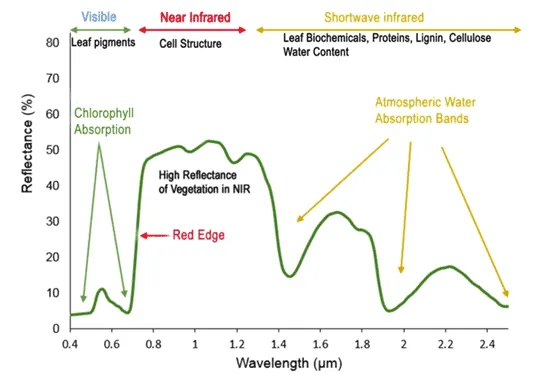
Fig.1: Spectral signature of vegetation (source: Roman, Anamaria & Ursu, Tudor. (2016). Multispectral satellite imagery and airborne laser scanning techniques for the detection of archaeological vegetation marks).
Why use drone sensors? The main objectives are:
- Analysing crop health by calculating vegetation indices (NDVI, VARI, NDRE, GNDVI depending on the sensor available).
- Optimising the resources used, thanks to the creation of dedicated prescription maps based on indices, for example for irrigation and fertilisation.
- Timely detection of pest and disease attacks, which are often invisible in their early stages.
- Supporting agronomic decisions with site-specific interventions.
Types of sensors
The drone flies over the crop at low altitude and collects information via a sensor. The main types of sensors are RGB, multispectral, thermal and LiDAR (Figure 2). Hyperspectral sensors also exist, but they remain the exclusive preserve of the research world due to their high purchase costs.
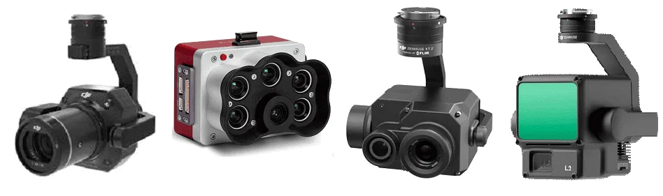
Fig.2: Examples of commercial sensors for each sensor type. From left: RGB, multispectral, thermal, LiDAR.
RGB sensors provide high-resolution images across the three primary colour channels: red (R), green (G) and blue (B). In practice, they simulate the human eye’s ability to observe the surrounding environment, working in a way similar to a smartphone camera. The advantage is the ability to acquire highly detailed images, from which it is possible to derive georeferenced maps of the field, 3D models, plant counts, visual analysis of crop condition and detection of visible damage. Multispectral sensors acquire images in bands of the electromagnetic spectrum not visible to the human eye, such as infrared and red edge. This allows a more in-depth analysis of plant health. In particular, it is possible to calculate accurate vegetation indices such as NDVI (Normalized Difference Vegetation Index), NDRE (Normalized Difference Red Edge Index) or GNDVI (Green Normalized Difference Vegetation Index). These indices are useful for the early detection of abiotic and biotic stress. Using vegetation indices, it is possible to build thematic maps representative of the field; for example, the NDVI index is used to create a vigour map (Figure 3). This map makes it possible to monitor canopy biomass and identify less vigorous areas.
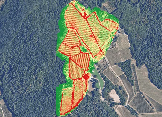
Fig.3: Vigour map obtained from the NDVI index in a vineyard.
Thermal sensors detect temperature variations in the canopy or soil, measuring surface temperature. This sensor was originally designed to monitor the efficiency of irrigation systems, but it can be used effectively to identify areas under water stress (leaves under stress tend to close their stomata and reduce evapotranspiration, increasing surface temperature) and to assess frost or heat-stroke damage. Data collected by the sensor can be translated into a thermal map (Figure 4), which makes it possible to analyse areas affected by thermal stress.
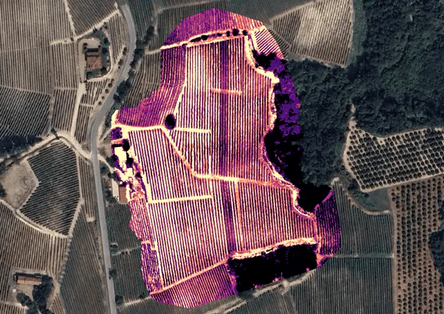
Fig.4: Thermal map of a vineyard based on a drone survey with a thermal sensor.
Finally, LiDAR sensors emit laser pulses and measure the time taken for the pulse to be picked up by the receiver. The time taken is translated into distance, generating a point. By repeating this process countless times, along a row for example, it is possible to build the three-dimensional point cloud of the plant’s canopy. Thanks to the 3D model, it is possible to calculate the plant’s biometric parameters (such as canopy volume, height and density) and create a “digital twin” (Figure 5 and Figure 6).
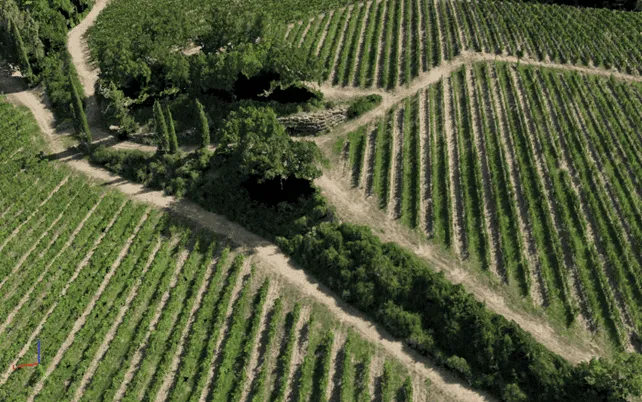
Fig.5: Digital twin of a vineyard.
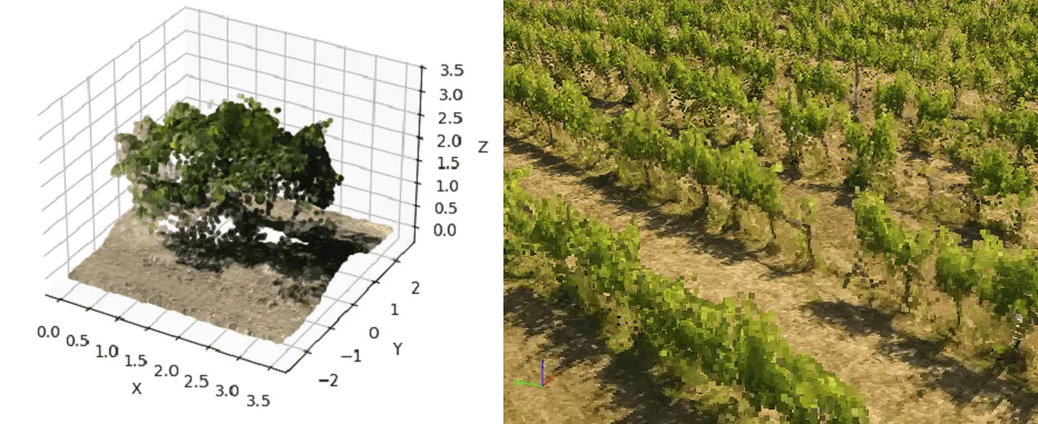
Fig.6: Digital twin of a citrus tree (left) and a row of vines (right).
Conclusions
The use of drone sensors allows farmers to work more rationally and objectively, reducing resource waste and increasing productivity. Despite their potential, it is important to be aware of certain limitations. Using drones requires technical skills and certified knowledge of airspace flight regulations. It is also important not to overlook the management and analysis of data obtained from drone remote sensing.
For exactly these reasons, an effective solution is to rely on Agrobit, which, with its iDrone service, provides expertise, technology and advanced infrastructure to bring precision agriculture directly into the field. With iDrone, the Agrobit team takes care of your field, from planned flights to data collection, and from map processing to decision support for the farmer. With iDrone, every flight is a winning choice!