
Drones in agriculture: planning a mission effectively
Drone flight mission: planning and best practices
Introduction
In precision agriculture, the drone is now an irreplaceable tool: it makes it possible to observe crops from above, collect visual, multispectral and thermal data, and turn information into targeted agronomic decisions. However, the quality of the data obtained and operator safety depend directly on how the flight is planned. There is often a tendency to consider the flight itself as the “central” moment of the mission, but in reality the most important part happens before take-off. Careful planning not only makes it possible to ensure the quality of the data collected, but also to operate in compliance with ENAC regulations, avoiding risks to people, property and equipment.
Setting up a flight correctly means defining a series of parameters in advance that directly influence the final outcome: image resolution, overlap between images, flight altitude, flight speed and the quality of the processed data.
Key parameters for the flight mission
The technical parameters that directly determine data quality are: flight altitude, side and frontal overlap, and flight speed. These parameters can be adjusted via the remote control interface. There are other parameters that are indirectly linked to the previous ones: estimated flight time and ground resolution.
- Flight altitude directly affects spatial resolution (or GSD, Ground Sampling Distance) and mission duration (the lower the flight altitude, the longer the mission duration). On the one hand, flying too high reduces the quality of detail. On the other, flying at too low an altitude means having to take more shots, resulting in higher battery consumption and longer times. Depending on the survey’s objective, it is necessary to choose a flight altitude that provides adequate resolution for it (e.g. for a weed survey, the flight altitude might need to be quite low to detect even small details).
- Managing frontal and side overlap between images is crucial for obtaining data that can be processed correctly, along with compliant maps and models. Overlap refers to the actual overlap between the image taken at one point and adjacent images (ahead, behind, sideways). Good overlap for ensuring good photogrammetric reconstruction is 70-80%. Insufficient overlap creates gaps and artefacts in the survey results, with the only solution being to repeat the flight with adequate overlap.
- Flight speed can be adjusted within a certain range set by drone manufacturers based on the other parameters mentioned above, meaning it is effectively a variable dependent on flight altitude (resolution) and desired overlap. Speed that is too high can cause “motion blur”, i.e. image blurring due to moving too quickly relative to the camera’s shutter speed. Conversely, speed that is too low reduces flight efficiency, resulting in a longer mission duration.
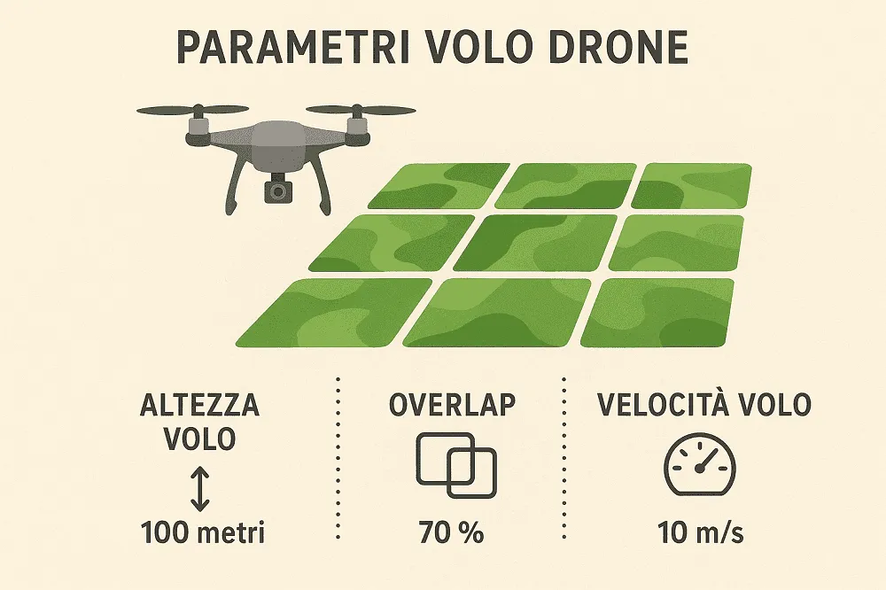
Fig.1: Main parameters of a drone mission.
Estimated flight time depends on altitude and flight speed. It is important to check this parameter, as it affects battery management, considering the possibility of splitting the mission into several stages (to change the battery).
Spatial resolution (cm/pixel) depends on flight altitude and sensor quality. In general, a multispectral sensor requires greater stability and precision, while a visible (RGB) camera can be used for coverage surveys.
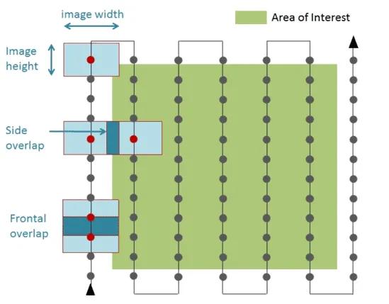
Fig.2: Frontal and side overlap between images. In green, the area of interest. In grey, the flight mission, with dots marking the sensor’s photo shots.
Common mistakes
Knowing the most common mistakes helps prevent them from happening. The first mistake is working with batteries that are not fully charged or have not been checked, which is one of the most common causes of sudden interruptions and data loss. Similarly, setting incorrect flight altitudes not only affects survey quality, but can also result in airspace regulation violations, with significant consequences. Another often underestimated aspect is sensor calibration: forgetting it means risking collecting images that are unusable or cannot be compared over time. Weather conditions also play a decisive role: strong wind, variable light and cloud cover (partial or total) can compromise the quality of the images acquired. Finally, the presence of obstacles such as trees, power lines or buildings, if not properly assessed, can turn a simple flight into a potential operational risk.
Taking care of every detail before take-off means drastically reducing the possibility of error and ensuring the collection of consistent, uniform data that is genuinely useful for agronomic analysis.
Pilot’s checklist
To avoid unexpected issues, it is useful to always have a checklist. It is equally important to customise the checklist based on your drone fleet and the type of survey you are carrying out.
An example checklist for using a drone in agricultural surveys is as follows:
In the days before the flight mission:
- Check the airspace (restricted zones, NOTAMs, CTRs, etc.)
- Check for any obstacles in the survey area (tall trees, pylons, etc.), congested areas or sensitive infrastructure
- Check the charge status of the drone and remote control batteries
- Check that the payload, propellers, motors and drone structure are undamaged
- Format the SD cards and make sure you have enough memory for the photos
- Check the weather forecast and the K-index (electromagnetic disturbance)
- Simulate the flight mission in the dedicated app
- Set the flight parameters and choose the best combination
- Save the flight mission with the parameters identified
- Make sure you have the documents needed to fly safely (licence, insurance) and any necessary authorisations
In the field at the time of the flight mission:
- Have spare batteries and an emergency kit (first aid kit, fire extinguisher) available
- Check the flight mission area to ensure regulatory compliance
- Check and clear the areas designated for take-off and landing
- Check for the presence of uninformed people in the flight area
- Calibrate multispectral sensors using dedicated calibration panels
- Carry out the mission while always maintaining visual control of the drone and the surrounding area
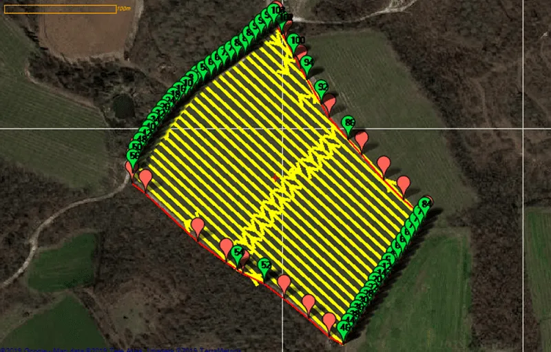
Fig.3: A typical drone mission in an agricultural setting.
Conclusions
Flight planning is a key step. Setting the parameters correctly before take-off means ensuring quality data from which to generate reliable maps. These maps must support agronomic decisions. For this reason, flight planning and the in-field flight itself must be considered an integral part of the work: it is the moment where technical expertise, field knowledge and attention to safety come together.
Thanks to the iDrone service, the Agrobit team takes care of everything. Our method involves flight planning, aerial image acquisition, and finally, we turn the data collected into maps that support agronomic decisions. In this way, farmers and agronomists can focus on what really matters: interpreting the maps and using objective data to make more informed, sustainable and profitable decisions.