
Precision agriculture app: how iAgro turns your smartphone into an agronomic tool
Precision agriculture app
Introduction
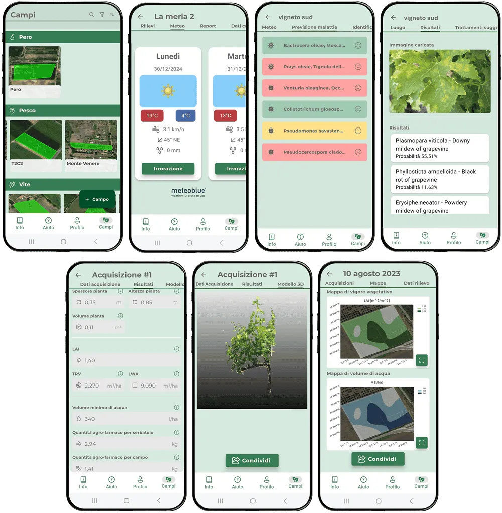
Technological evolution is shaping a new era in crop monitoring. In this context, the use of advanced monitoring techniques is revolutionising crop management, allowing farmers to access real-time tools and data to optimise production and preserve harvest quality. Among Agrobit’s solutions is iAgro, the first mobile DSS (Decision Support System) app for smartphones capable of providing guidance on how to reduce and optimise crop protection treatments and create vigour maps for tree crops simply using your smartphone, providing precise, objective data that opens the door to advanced, sustainable farm management.
The app turns the smartphone into a 3D scanner capable of generating a digital twin (3D model) of the scanned crop, which is then analysed in the cloud using proprietary computer vision (CV), augmented reality (AR) and artificial intelligence (AI) algorithms, in order to obtain the crop’s biometric parameters (canopy thickness, height and volume), biophysical vigour parameters such as LAI (Leaf Area Index), LWA (Leaf Wall Area), TRV (Tree Row Volume), and finally the optimal dose of water and pesticide for that specific area of the field. By repeating scans at multiple points in the field, the app makes it possible to generate vigour and prescription maps.
iAgro can be used effectively by farmers, agronomists and agricultural technicians, associations and consortia, agrochemical industries and testing centres, making it possible to reduce pesticide dispersion into the environment by up to 50%, lower residue build-up in groundwater, lower risk to operators and rural communities, and lower impact of residues on the food chain. All of this is in line with the European Green Deal, the Farm-to-Fork strategy and the CAP, whose general objectives include reducing the risks and impacts of crop protection products on human health, the environment and biodiversity, as well as protecting users of crop protection products and the population concerned.
The app is a fast, cost-effective, scalable tool for precision agriculture that generates thematic maps to improve decisions in the field, using objective data. The technology used was specifically designed to spread digital agriculture techniques as widely and cheaply as possible among farmers and technicians, using nothing more than a widely available device — the smartphone, which becomes an agronomic survey tool — all factors that are crucial for spreading precision agriculture practices among micro, small and medium-sized farms, which make up the majority in Europe.
How the iAgro app works
The iAgro app has the following main features: 1. Creating a register of the farm’s plots. Users can draw their own plots, indicating the name, crop type (vine, traditional olive, intensive olive, apple, pear, peach, citrus, almond) and row spacing (for row crops) or the number of trees present in the plot (for traditional olive groves) (Fig. 1). Once created, the plot’s perimeter and area can also be viewed;
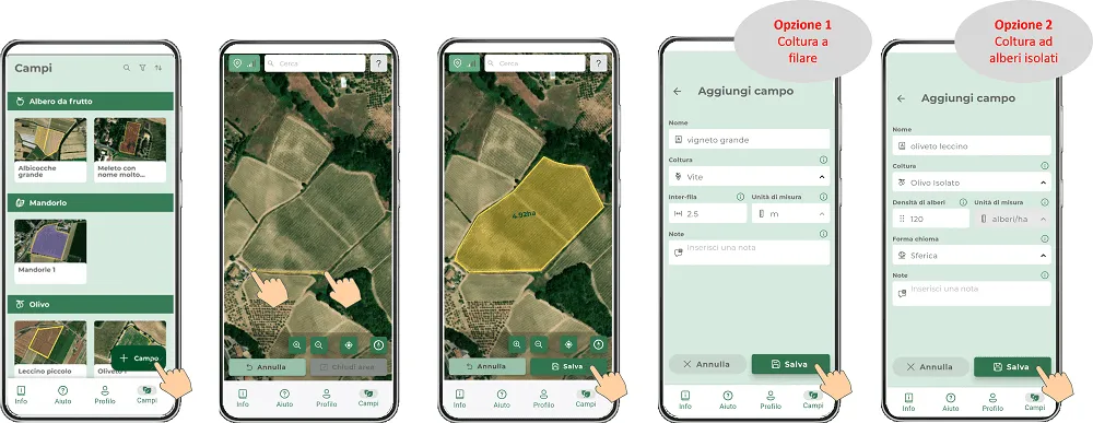
Fig.1: Creating a plot and its register entry.
2. Creating surveys within the plot. Once the plot has been created, one or more surveys can be created within it, where you can enter the phenological stage, the adversity to be tackled, the type of sprayer used for treatments, the sprayer tank volume, the recommended pesticide dose from the manufacturer’s label, and its unit of measurement (Fig. 2);
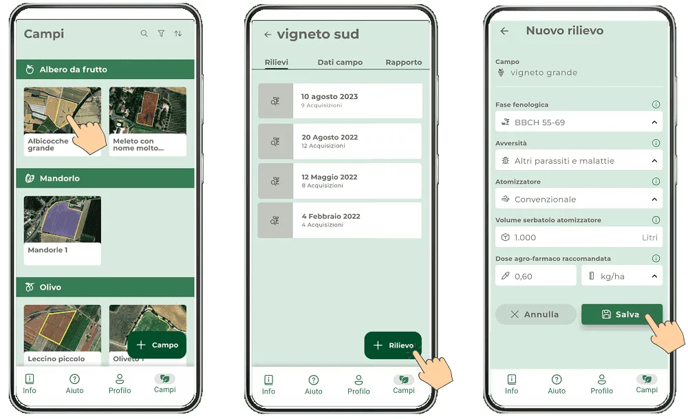
Fig.2: Creating a survey.
3. Creating acquisitions. Once the survey has been created, one or more acquisitions can be created within it, allowing you to perform a 3D scan of the row section or tree to be analysed (Fig. 3);
Fig.3: 3D scanning for row crops (top) and for isolated trees (bottom).
4. Crop biometric and biophysical parameters. Once the scan has been performed and the photos uploaded to the cloud, results are available within a few minutes. Specifically:
- canopy height, thickness and volume
- the LAI (Leaf Area Index) vigour index
- the LWA (Leaf Wall Area) vigour index
- the TRV (Tree Row Volume) vigour index
- the optimal water dose for crop protection treatments for each zone of the field and at each phenological stage
This data can be viewed and exported in table format directly from within the app (Fig. 4);
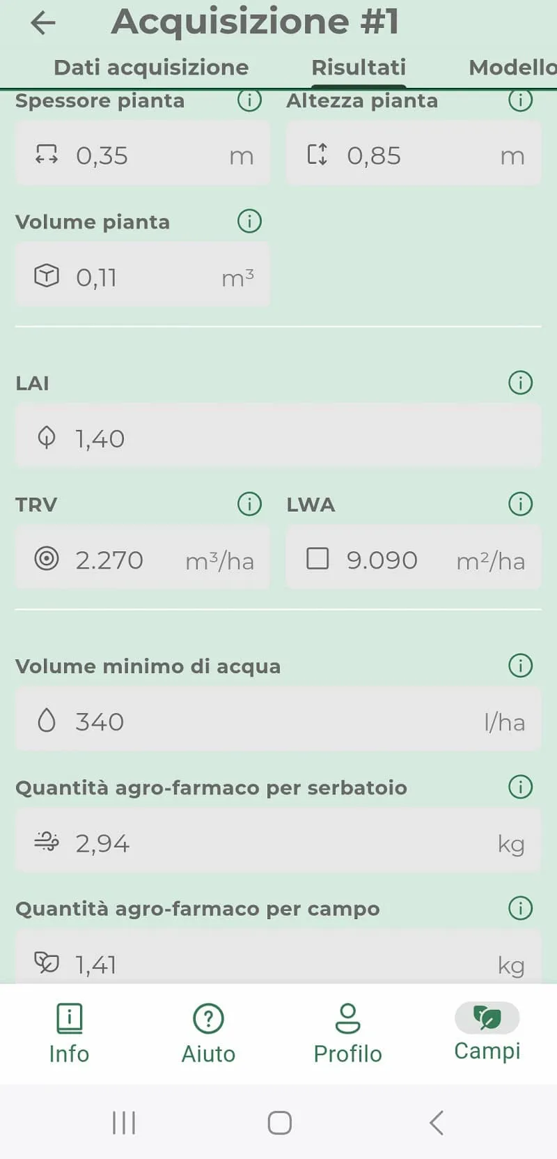
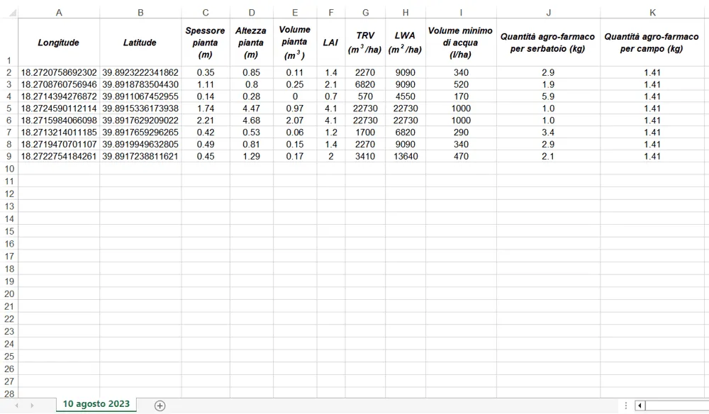
Fig.4: Viewing and exporting 3D scan results.
5. Generating your crop’s digital twin. In addition to the results described in the previous point, you can also view the 3D model of the scanned row section or tree (Fig. 5);
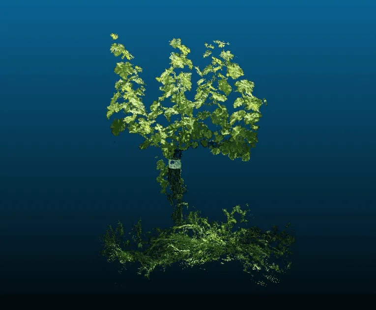
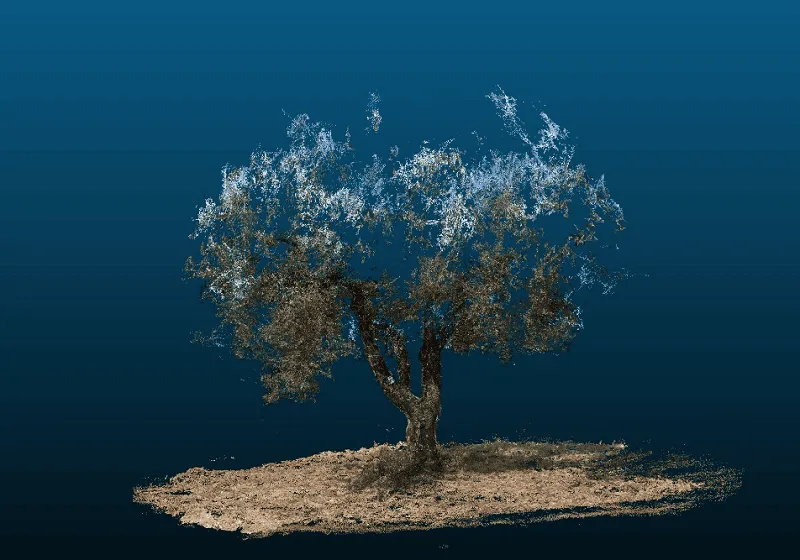
Fig.5: 3D models (digital twins) for row crops (left) and for isolated trees (right).
6. Vegetative vigour maps and prescription maps for optimised crop protection treatments. By repeating scans at a sufficient number of well-distributed points in the plot (minimum 5), vegetative vigour maps (LAI index) are automatically generated, to optimise fertilisation, irrigation and fruit harvesting on a site-specific basis. At the same time, a three-zone prescription map is also created for variable, optimised crop protection treatments, based on the actual needs of your crops. Both maps can be exported in raster (.tiff), vector (.shp) and image (.jpeg) formats (Fig. 6);
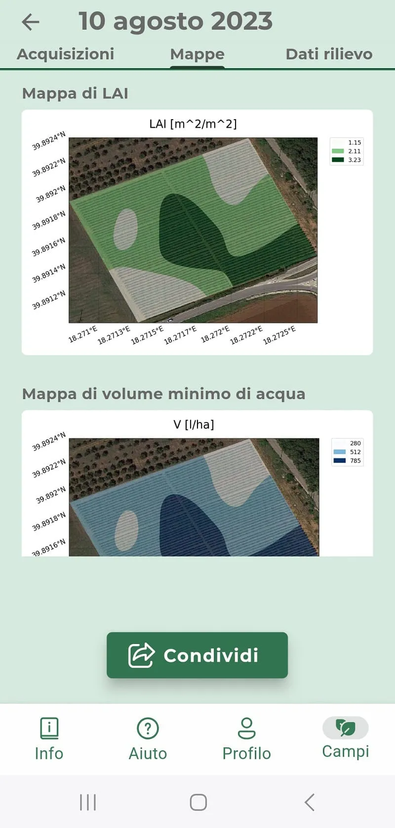
Fig.6: Viewing and exporting the vigour map (LAI) and the prescription map for crop protection treatments.
7. Build your plot’s history. By carrying out multiple surveys over time within the same plot, you can create a timeline for it and keep a historical record of data and maps. This is useful for making better agronomic decisions and comparing seasons with one another, as well as making it possible to communicate all information to certifying bodies or public administrations in a traceable way (Fig. 7);
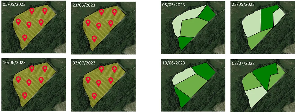
Fig.7: Plot history in terms of vegetative vigour.
Conclusions
Managing crops with pesticides and fertilisers has a significant impact on a farm’s economic and environmental balance. It is important to implement the streamlining of farming practices that characterise crop management, using tools that reduce environmental impact, making the farm more sustainable and competitive on the market and in line with new regulations.
Through iAgro, Agrobit is committed to providing a simple, cost-effective tool for optimising crop protection treatments and creating vigour maps to improve fertilisation and harvesting, paving the way for more efficient, eco-sustainable farm management. Using vigour and prescription maps gives farmers the opportunity to adopt a more targeted approach, significantly helping to improve final product quality and reduce resource waste.
This tool is not only affordable, but also represents a strategic investment for farmers who want to build a business identity that keeps pace with the times and stand out distinctly on the market. Combining the use of iAgro with targeted farming practices results in a dual benefit: improving farm profitability and contributing to more sustainable farm management in the long term.
For more information on how the app works, you can visit the dedicated section on the website or watch the video tutorial.