
Project: AgroTwin, AI and computer vision to optimise crop protection treatments
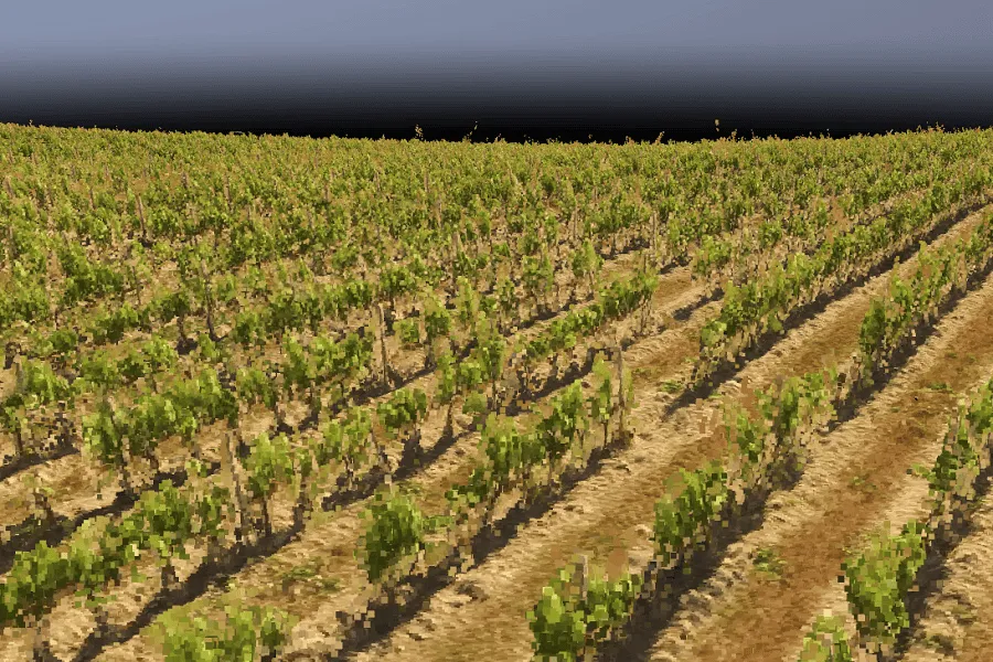
AI and Computer Vision to analyse vineyards and optimise crop protection treatments
Introduction
Technological innovation is increasingly present in the world of agriculture, and the AgroTwin sub-project, funded with €60k by the Horizon Europe ICAERUS project, is a perfect example of this. ICAERUS is a project focused on exploring the potential of drones as multi-purpose tools for agriculture, environmental monitoring and rural services. The goal of the AgroTwin sub-project was to develop and test a Decision Support System (DSS) based on advanced AI and computer vision algorithms to optimise crop protection treatments using consumer-grade drones, such as the DJI Phantom 3 Professional (Fig. 1).
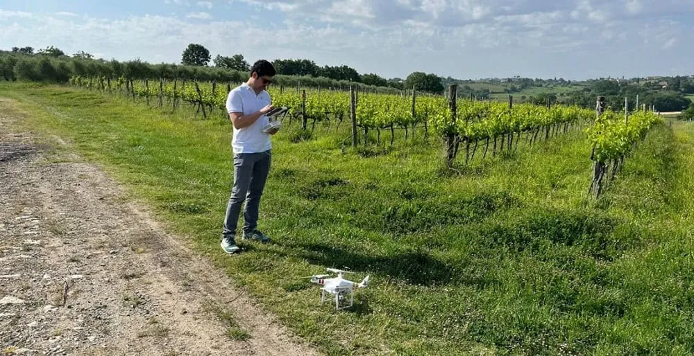
Fig.1: Preparing the DJI Phantom 3 Professional for flight in the test vineyard.
A Decision Support System for Sustainable Agriculture
Image collection and algorithm testing were carried out on a Sangiovese vineyard of around 1.2 ha at the regional Cesa estate (AR) (Fig. 2). This was divided into 2 plots of similar size and vegetative vigour, one used for variable-rate dosing of pesticides based on the results of our DSS (test), and the other for fixed doses (control), where the farm’s standard doses were applied.
To capture visible (RGB) images of the vineyard, we used an easy-to-use, widely available consumer drone, the DJI Phantom 3 Professional. These images were used to generate 3D point clouds, which allowed us to create the vineyard’s digital twin at three different phenological stages.
For each flight, proprietary algorithms were used to precisely analyse the digital model in order to extract the main biometric parameters of individual vines of interest. Using this data, the DSS generated customised prescription maps for variable rate treatments (VRT), improving the efficiency of pesticide application.
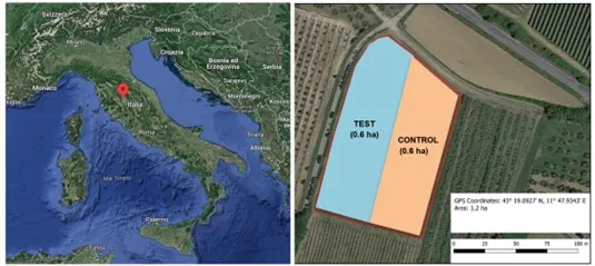
Fig.2: Location of the test vineyard and division into the two plots (test, control).
Advanced Algorithms for Biometric Parameter Analysis
One of the most innovative aspects of AgroTwin was the development of advanced AI and computer vision algorithms to analyse vine biometrics. These algorithms, applied to the 3D point clouds generated by the drone, made it possible to precisely analyse the main parameters of interest, such as the thickness, height and canopy volume of individual vines of interest, with an average error margin of less than 10% compared with manual measurements (Fig. 3, 4).
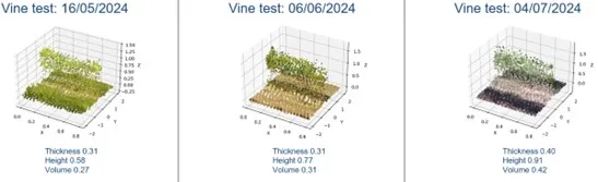
Fig.3: Evolution across the different phenological stages of a test vine (thickness (m), height (m), volume (m³)).
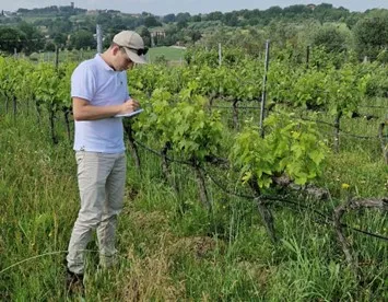
Fig.4: Manual measurements in the field.
Using these biometric parameters, the algorithms made it possible to build a very important vigour index, the LAI (Leaf Area Index), as well as generating the LWA (Leaf Wall Area) and TRV (Tree Row Volume), which indicate the surface area and volume of the vineyard’s canopy. By interpolating a suitable number of sample plants, the algorithms automatically generated vegetative vigour maps (LAI) and prescription maps for crop protection treatments (Fig. 5).
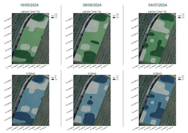
Fig.5: Vigour maps (LAI) and prescription maps (litres/hectare) for crop protection treatments at each phenological stage.
Sensitivity Analysis to Improve Data Collection
Another crucial phase of the project was the sensitivity analysis to find the best drone survey flight parameters, providing the best compromise between data quality and flight time. This study made it possible to identify the best flight configurations to ensure the best accuracy in estimating vine canopy parameters compared with manual measurements. The best configuration, with errors of less than 10% compared with manual measurements, proved to be a flight altitude of 30 metres, with 85% overlap between photos, and combined camera angles (nadir and 30°), which significantly improved the accuracy of the data collected.
Environmental and Economic Benefits
To assess the quantity and quality of pesticide deposition on vine canopies in the two different zones, an internationally standardised procedure (ISO 22522) and a food-grade tracer (tartrazine) were used. The main goal was to compare the efficiency of the two treatment types. Surveys on treatment effectiveness were carried out by the Department of Agricultural Mechanics (DAGRI) at the University of Florence.
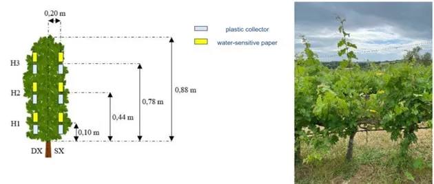
Fig.6: The procedure involved sampling three representative vines in low, medium and high vigour areas, using water-sensitive paper and nylon collectors placed at three different canopy heights (H1 above the cordon, H2 mid-canopy, H3 at the top).
The results showed that average coverage was 35% in the VRT plot, slightly above the optimal threshold (30%), but the vine canopies were covered according to their actual biomass, while the control plot recorded average coverage of 39%, without taking actual field biomass into account. Finally, no disease was detected in the tested plots, and no significant differences were found in grape yield and quality at the time of assessment. As for dosage, thanks to the VRT approach, an average reduction of 35% in pesticide and water use was achieved, with a peak of 41% during the intermediate phenological stage. These savings can translate into a reduction in the environmental impact of these products, helping to preserve biodiversity in the vineyard and limit pollution of groundwater and air.
Conclusions
The AgroTwin project represents a step forward in precision agriculture, using imagery to support agronomic decision-making. Thanks to this project, a DSS prototype based on drone imagery was designed. It was also assessed to what extent the integration of drones and advanced algorithms can improve the environmental and economic sustainability of farming operations.
The project demonstrated how using a drone that takes simple RGB photos can generate digital models of sufficient quality to analyse a crop in the field and obtain prescription maps usable for the most important operations, such as pesticide distribution or selective harvesting based on vegetative vigour, thereby making it possible to save valuable resources and improve production processes.
Thanks to the significant savings in pesticide and water quantities, and better distribution in the field, the DSS developed positions itself as an innovative, sustainable agronomic tool that makes it possible to pursue the principles of precision agriculture by using digital copies of the vineyard. In a sector increasingly oriented towards sustainability, this technology can offer farmers a practical, cost-effective and cutting-edge solution for tackling the current challenges of modern agriculture.
Find out how to optimise treatments with the iAgro app or the iDrone service!